
Overview
Route Details

Route Description

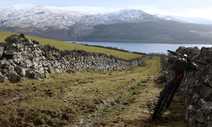
Starting at Rannoch Station, the route follows the B 846 eastbound. With not many options to go other than Rannoch Station, this is a quiet tarmac road that offers stunning views on a good day. Passing Loch Eigheach and the power station the road then follows the River Gaur and passes the turnoff to Bridge of Gaur. Shortly afterwards a gravel track to Rannoch Lodge leaves the road on the left. Climbing gradually into the forest, this is the route of the Highland Trail 550, which is followed for a while. The well-maintained gravel track follows over open heather land until it joins another track on a fork just before another forested area. The views from here to the south and west over the mountains are breathtaking. The route continues through a deer gate into more open moorland, reaching the highest point at 360 m. With more stunning views over Loch Rannoch and towards Schiehallion the track descends towards Camusericht Lodge. Please be aware that the route crosses a private property with dogs, which requires caution.
From Camusericht the route follows the B 846 again along the shores of Loch Rannoch. This is the route of the former Road to the Isles from Pitlochry to Lochaber, which continues as a gravel track past Rannoch Station (and provides a good connection to Fort William and the Isles). Loch Rannoch is the ninth-largest freshwater loch in Scotland, with a unique population of Arctic charr. It’s likely that this was the first freshwater fish to colonise Scotland after the last ice age, with three different variations found in the loch. The ride along the northern shores of the Loch Rannoch is pleasant, with a mixture of open views and trees to provide shelter.
At Aulich the route leaves the road again to climb on a well-maintained gravel track past Craiganour Lodge into the open Highland landscapes, with spectacular views towards the Cairngorm Mountains. The track reaches its highest point at 370 m shortly after a fork, where the route follows a track southeast. The section from here can be very wet and boggy after prolonged rain and in the winter. The descent offers more great views towards Schiehallion. Easily visible in the heathland is the historic settlement of Tor a’Chruidh, locally known as Annat Village. The route then turns south and passes through farmland, where a herd of Highland cows is residing all year around. In wet weather and calving season this section of the route is best avoided. As an alternative follow the road, which the route meets again at Annat. Shortly after passing a hotel a path on the left provides a great alternative to the tarmac road, which is rejoined just before Kinloch Rannoch.
Kinloch Rannoch has a shop, cafe and places to stay. The route follows a walking path towards the River Tummel to an impressive weir, and then passes underneath the bridge over the Tummel, dating back to 1764. A set of steps leads back onto the road. This can be avoided by staying on the road and taking a right turn in the village. The route follows the road close to the shore first, which offers great spots for a rest and passes a memorial and a smokehouse. This is also part of the Clan Trail, which tells the story of the seven clans that lived in this wild and inhospitable area in days gone by.
The route then heads eastbound and joins the Schiehallion road again. This road, passing the iconic mountain on its southern slopes, is a popular road with road cyclists and climbs steadily towards Braes of Foss. Caution is needed on blind corners. At the Braes of Foss car park the route includes a newly-established walking loop on good tracks and north shore trails into the moorland. A few benches and a toilet make this a good point to rest. Back on the road, the route climbs to the highest point of the Schiehallion Road at 380 m at Loch Kinardochy, before it joins the B 846 towards Aberfeldy, following another section of Wade’s Military Road.

At Coshieville the route enters Glen Lyon, billed as Scotland’s longest, loneliest and loveliest glen. A minor road takes you first to Fortingall, passing the Keltneyburn Smithy, an art gallery with some impressive sculptures made of recycled materials. Standing in the grounds of the church, the Fortingall Yew is an ancient European yew, known for being one of the oldest trees in Britain, with modern estimates believing it to be between 2,000 and 3,000 years old. A small hotel offers food and rooms, while the street lanterns in the village are very distinct.
The route continues on tarmac to Invervar, passing the ruins of Carnbahn Castle, before it branches off to a carpark on the left. From here a track with small sections of tarmac follows south of the River Lyon to Kerrowmore of Balgie, and back on the road to Bridge of Balgie. The cafe/tea room here is a popular stop for cyclists.
After Bridge of Balgie the route follows the road east to Glenlyon Church at Innerwick, where St Adomnán’s Bell is believed to date back to the 700s. It was found in the churchyard of the ruined St Brandon’s Chapel in the glen. The next section is a classic off-road ride in Scotland, included in the Highland Trail, Great North Trail and Central Belter. An old drove road, known as the Kirk Road through the Lairig Ghallabhaich, it follows a track to the pass at 478 m. This is a steep climb on a landrover track, but offers fantastic views. The route continues down along the Allt Droilichean and into the forest, until the stream turns northeast. This area, known as the Black Wood of Rannoch, contains some of the largest areas of ancient pine forest in Scotland. Some of the trees are thought to be hundreds of years old, and it is home to a rich variety of plants, insects, birds and animals.
At a junction the route leaves the Kirk Road and continues on a well-graded forest track past a small lochan, before heading west through the forest, eventually crossing the Allt Camghouran. The route climbs past Leagag and then descends north to Bridge of Gaur, on the western end of Loch Rannoch. From here the route crosses the River Gaur and rejoins the B 846 with a gradual climb back to Rannoch Station.

Route Map
Local Services
Discover and support local businesses along the route.
Bike Services & Rentals
If you're in need of some extra supplies, a hand with some quick bike repairs or looking to hire something new, you can rely on our trusted friends below.
